Planning a road trip and wondering how far it is from San Francisco to Sequoia National Park? The drive spans roughly 280 to 300 miles, taking about 5.5 to 6.5 hours depending on the route and seasonal conditions. Whether you’re headed straight to explore giant sequoia trees or creating a scenic California road trip, this guide covers travel routes, tips, and must-see stops. For more detailed advice on travel planning, explore our complete guide on how far Sequoia National Park is from San Francisco.
Distance Between San Francisco and Sequoia National Park
The distance from San Francisco to Sequoia National Park varies slightly depending on the route taken, but the most direct path covers approximately 280 to 300 miles (450 to 480 kilometers). The journey leads travelers from the bustling streets of San Francisco through the Central Valley and into the foothills of the Sierra Nevada, where the park is located.
Average Travel Time
Under normal driving conditions, the trip from San Francisco to Sequoia National Park takes approximately 5.5 to 6.5 hours. However, travel time can vary depending on:
- Traffic conditions in the Bay Area, especially during peak hours.
- Weather-related delays, particularly in winter months when snow can affect roads in and around the park.
- Route selection, as some scenic or alternative routes may be longer but offer additional attractions along the way.
Recommended Driving Routes
There are several common driving routes from San Francisco to Sequoia National Park:
Via I-580 E and CA-99 S (Fastest Route)
- Distance: ~280 miles
- Estimated Time: 5.5 to 6 hours
- Route Description: This is the most direct and typically fastest route. It takes you southeast out of San Francisco through the East Bay, connects with CA-99 S in the Central Valley, and then transitions to CA-198 E into the park via the Ash Mountain Entrance.
Via US-101 S and CA-198 E (Scenic Route)
- Distance: ~310 miles
- Estimated Time: 6.5 to 7 hours
- Route Description: This route travels down the California coast before cutting inland toward Sequoia. It’s a good option if you're including Monterey or Pinnacles National Park in your itinerary.
Via I-5 S and CA-198 E
- Distance: ~290 miles
- Estimated Time: 6 to 6.5 hours
- Route Description: This alternative utilizes the interstate for long stretches, which can be faster depending on traffic. It’s a good option for avoiding congestion on CA-99.
Entry Points to Sequoia National Park
Most visitors enter Sequoia National Park via the Ash Mountain Entrance near the town of Three Rivers on CA-198. This entrance is accessible via all major routes from San Francisco and is open year-round, though winter weather may require tire chains or 4WD vehicles.
An alternative is the Big Stump Entrance on CA-180, which connects more directly to Kings Canyon National Park and is often used in combination for travelers planning to visit both parks.
Travel Time Variations by Season
- Summer (June to August): Expect heavier traffic and longer park entry wait times during peak tourist season.
- Winter (December to February): Snow and ice can make certain roads hazardous or closed. Travel time may increase, and vehicle restrictions may apply.
- Spring and Fall (March to May, September to November): These shoulder seasons offer the best balance between favorable weather and fewer crowds, with relatively consistent travel times.
Fuel and Rest Stops
Along the way, travelers will find ample opportunities to stop for fuel, food, and rest in Central Valley cities like Modesto, Merced, Fresno, and Visalia. Visalia, in particular, is a popular overnight stop and the closest major city to the park’s southern entrance.
Driving Tips
- Check road conditions before departure, especially in winter months.
- Fill up on gas before entering the park, as fuel is not available within Sequoia National Park.
- Start early to maximize daylight hours and avoid afternoon congestion.
- Use GPS or a reliable map, but be aware that cell service can be limited in mountainous areas. Download offline maps when possible.
Route Options
When planning a trip from San Francisco to Sequoia National Park, travelers have several scenic and practical route options to choose from, each offering unique experiences along the way. The total driving distance is approximately 230 to 280 miles (370 to 450 kilometers), depending on the chosen route, with an average driving time of 4.5 to 6 hours without stops. However, given the numerous attractions and natural landmarks en route, many travelers opt to extend the journey into a multi-day road trip.
Route 1: Direct Route via I-580 E and CA-99 S
This is the most efficient and commonly used route for travelers looking to reach Sequoia National Park quickly from San Francisco:
- Route: Take I-580 E through the East Bay, connect with I-205 E through Tracy, then merge onto CA-99 S at Manteca, continuing through central cities like Modesto and Fresno. From Fresno, head east on CA-180 E and finally south on CA-198 E to reach the park entrance.
- Distance: Approximately 230 miles
- Driving Time: Around 4.5 to 5 hours
- Highlights: Fastest route, ideal for those on a tight schedule; pass through the agricultural heartland of California's Central Valley.
Route 2: Scenic Coastal and Inland Route via Monterey and Pinnacles
This route is ideal for travelers seeking a more scenic and leisurely drive, incorporating coastal and inland attractions before reaching Sequoia:
- Route: From San Francisco, take US-101 S to Monterey for coastal views and marine wildlife; continue to Pinnacles National Park via CA-1 and CA-25. Then head east to Visalia via CA-198 E, a gateway town to Sequoia National Park.
- Distance: Approximately 350 miles total with detours
- Driving Time: 6 to 8 hours total driving time, recommended as a 2-3 day route
- Highlights: Pacific coast scenery, Monterey Bay Aquarium, Pinnacles’ unique rock formations, wildlife, and small-town charm in Visalia.
Route 3: Sierra Foothills Adventure via Yosemite and Kings Canyon
For those with additional time and a desire to explore multiple national parks, this route offers a majestic detour through Yosemite and Kings Canyon before arriving at Sequoia:
- Route: From San Francisco, take I-580 E to CA-120 E to reach Yosemite National Park. Continue south on CA-41 to Fresno, then east on CA-180 E through Kings Canyon National Park. Finally, connect to Sequoia via the Generals Highway (CA-198).
- Distance: 400+ miles depending on exact path
- Driving Time: 8 to 10 hours total, best split over 3 to 4 days
- Highlights: Iconic Yosemite Valley, towering cliffs, alpine meadows, and the dramatic landscapes of Kings Canyon. Ideal for national park enthusiasts.
Seasonal Considerations
- Winter Travel: Some mountain roads, including the Generals Highway connecting Kings Canyon and Sequoia, may be closed due to snow. Chains may be required for vehicles.
- Spring and Summer: Ideal for road trips, with clear roads and access to all park areas. Wildflowers and waterfalls are abundant in spring.
- Fall: Offers cooler temperatures and fewer crowds, making it a great time for hiking and photography.
- Check Conditions: Always verify current road and weather conditions via Caltrans or the National Park Service before departure, especially if traveling through mountainous areas.
Each route offers its own unique set of experiences, whether you're looking for the fastest way to reach the park or prefer to enjoy California’s diverse landscapes along the journey.
Key Stops Along the Way
Embarking on a road trip from San Francisco to Sequoia National Park offers a diverse array of landscapes and attractions, from coastal towns to rugged mountains and ancient forests. Along the approximately 280-mile journey—typically taking 5 to 6 hours of direct driving—there are several key stops that enrich the experience and break up the drive into manageable, adventure-filled segments.
Monterey
Located about two hours south of San Francisco, Monterey is a scenic coastal town known for its vibrant marine life and historic significance. The world-renowned Monterey Bay Aquarium is a standout attraction, offering immersive exhibits featuring sea otters, jellyfish, and kelp forests. Cannery Row, once a center of sardine-packing, is now a bustling waterfront street with shops, galleries, and restaurants. Visitors can also explore the nearby 17-Mile Drive, which offers stunning coastal views and passes through Pebble Beach and Pacific Grove.
Pinnacles National Park
Roughly 1.5 to 2 hours from Monterey, Pinnacles National Park is a hidden gem and one of the newest additions to the national park system. Known for its dramatic rock spires, talus caves, and rare California condor sightings, it offers excellent hiking opportunities. Popular trails include the Bear Gulch Cave Trail and the High Peaks Trail, both rewarding visitors with panoramic views and unique geological formations. The park is ideal for a half-day stop or an overnight camping experience.
Visalia
As the closest major city to Sequoia National Park, Visalia serves as a practical and comfortable overnight stop. Located about 2 hours from Pinnacles and just under an hour from the park’s entrance, it offers a range of accommodations, restaurants, and supply stores—making it an ideal base for preparing before heading into the mountains. Downtown Visalia features charming boutiques, local eateries, and tree-lined streets, providing a relaxed ambiance before the adventure continues.
Sequoia National Park
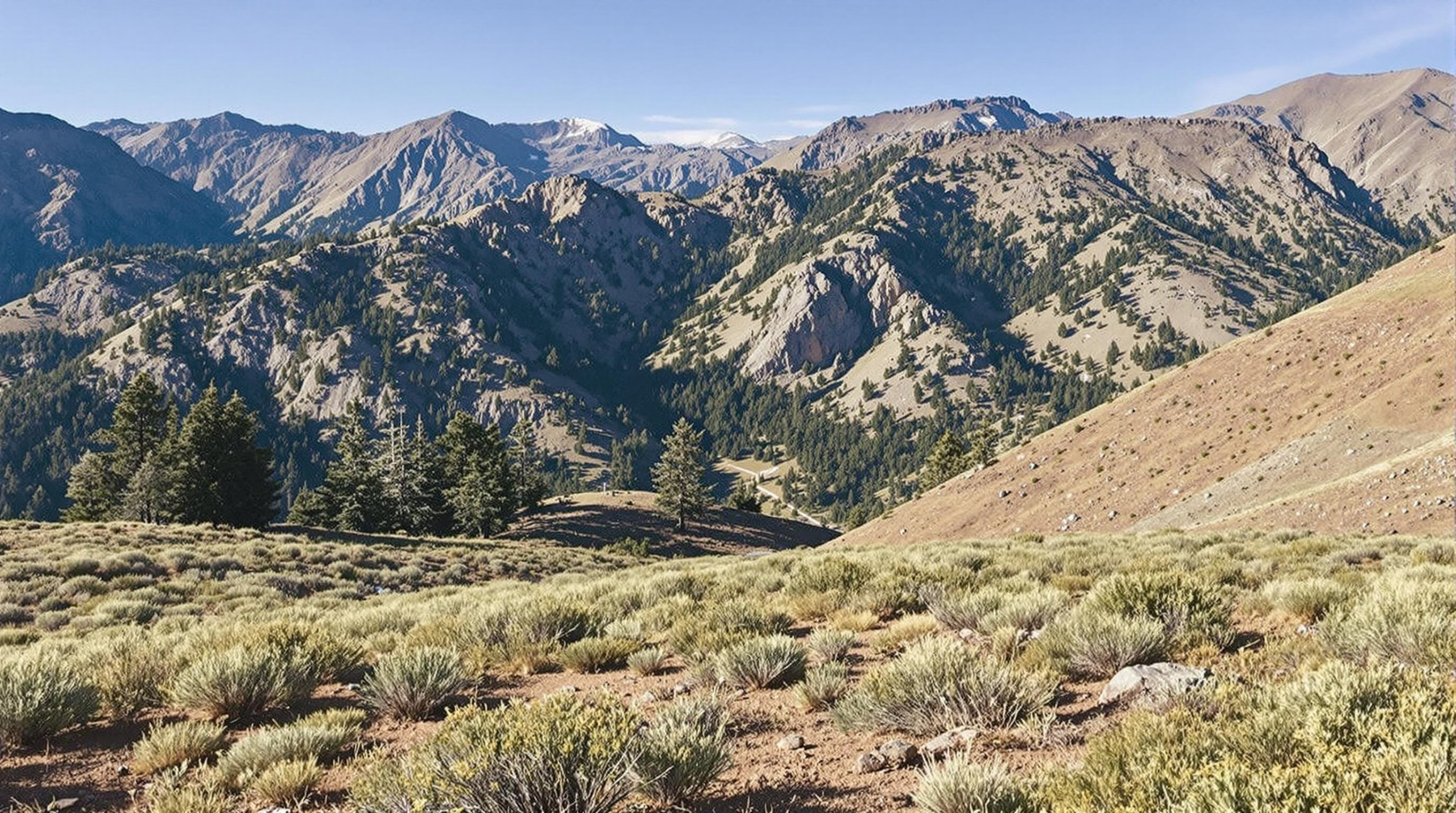
One of the main destinations of the journey, Sequoia National Park is home to towering groves of ancient trees, including the General Sherman Tree—the largest tree on Earth by volume. Other highlights include the Giant Forest, Moro Rock (a granite dome offering panoramic views), and the Tunnel Log, a fallen sequoia that visitors can drive through. The park's scenic byways, such as Generals Highway, wind through breathtaking mountain landscapes and offer numerous trailheads for both casual walks and challenging hikes.
Kings Canyon National Park
Often visited in conjunction with Sequoia, Kings Canyon National Park is just a short drive away via the Generals Highway. Known for its deep canyons, high mountain peaks, and roaring rivers, Kings Canyon offers a different perspective on California's wilderness. Key attractions include Zumwalt Meadow, the Kings River Canyon Scenic Byway, and Roaring River Falls. The park's Grant Grove is home to the General Grant Tree—another massive sequoia and a designated national shrine.
Together, these key stops create a rich and varied itinerary that showcases the best of central California—from coastal beauty and geological wonders to alpine forests and ancient giants.
Driving Duration and Distance
The journey from San Francisco to Sequoia National Park covers approximately 280 to 300 miles, depending on the chosen route. On average, this drive takes between 5.5 to 6.5 hours without extended stops. The most direct route typically follows US-101 S to CA-152 E, then connects to CA-99 S, before heading east via CA-198 E into the park through the Ash Mountain Entrance near Three Rivers. This route offers a balance of highway efficiency and scenic value.
If time allows, incorporating detours through destinations like Monterey or Pinnacles National Park can enhance the experience, increasing both the total distance and travel time but adding rewarding stops along the way.
Best Time to Visit
The ideal time to visit Sequoia National Park is from late spring to early fall (May through October). During this period, road conditions are most favorable, and park facilities are fully operational. Summer months offer warm temperatures and clear skies, making it perfect for hiking and camping. However, it is also the park’s busiest season.
Spring and early fall present fewer crowds and milder temperatures, with the additional benefit of wildflower blooms in spring and vibrant foliage in fall. Winter visits are possible but come with limitations due to snow, road closures, and chain requirements, especially on mountain roads such as Generals Highway.
Route Options and Recommendations
There are several route options depending on your planned itinerary:
- Direct Route (via CA-99 S and CA-198 E): This is the fastest and most straightforward path, taking about 5.5 to 6 hours.
- Scenic Coastal Route (via Monterey and Pinnacles): Travel down California’s coast via Highway 1, stopping in Monterey, then head inland through Pinnacles National Park before reconnecting with the main route to Visalia and Sequoia. This adds scenic value but extends driving time to 7+ hours.
- Yosemite Detour (multi-park route): For those with more time, consider a loop that includes Yosemite National Park before heading south to Sequoia via the Sierra Nevada. This is best for extended trips and offers a broader experience of California’s national parks.
Keep in mind that access to Sequoia through the Kings Canyon entrance (via CA-180) is also possible when combining visits to both parks, though it may require additional driving time.
Required Permits and Passes
To enter Sequoia and Kings Canyon National Parks, visitors need a valid entrance pass:
- Standard Vehicle Pass: $35 per vehicle, valid for 7 consecutive days.
- America the Beautiful Pass: $80 annual pass providing access to all U.S. national parks and federal recreational lands.
- Free Entrance Days: Several days throughout the year offer free entry — check the National Park Service website for dates.
If camping or staying overnight within park boundaries, additional permits or campground reservations may be required. For backcountry hiking or overnight wilderness trips, a wilderness permit must be obtained in advance, especially during peak season.
It’s also important to check for seasonal road conditions and any temporary restrictions before departure. The National Park Service provides up-to-date alerts, including weather-related closures and fire advisories.
Additional Considerations
Weather and Road Conditions
When planning your road trip from San Francisco to Sequoia National Park, it's important to be aware of the changing weather and road conditions, especially in mountainous regions. The Sierra Nevada mountains can experience sudden weather shifts, particularly in winter and early spring, which may lead to road closures or snow chain requirements on highways such as CA-198 or CA-180. Always check the National Park Service (NPS) website and Caltrans for real-time updates on road conditions before and during your travel.
Sequoia National Park, due to its elevation (ranging from 1,300 to over 14,000 feet), can have snow on the ground well into late spring. Summer and early fall typically offer the most favorable driving conditions for accessing higher elevations like Moro Rock and the Giant Forest.
Altitude Awareness
Sequoia and Kings Canyon National Parks are situated at high elevations. Many popular areas, including Lodgepole and Giant Forest, are located above 6,000 feet. Visitors not acclimated to higher altitudes may experience symptoms of altitude sickness such as headaches, dizziness, or nausea. To minimize discomfort, stay hydrated, rest frequently, and avoid strenuous activities on your first day in the park.
Wildlife Safety
Both Sequoia and Kings Canyon are home to diverse wildlife including black bears, deer, mountain lions, and numerous smaller animals. Proper food storage is critical, especially if you're camping or traveling by campervan. The parks require food and scented items to be stored in bear-proof lockers or containers. Feeding wildlife is strictly prohibited and can result in fines or create dangerous situations for both animals and visitors.
Cell Service and Connectivity
Cell phone service is extremely limited or nonexistent in most parts of Sequoia and Kings Canyon National Parks. Plan accordingly by downloading offline maps, saving key information, and informing someone of your itinerary and expected return time. Visitor centers and some lodge areas may offer limited Wi-Fi, but these should not be relied upon for navigation or emergency contact.
Fuel Availability
There are no gas stations within Sequoia or Kings Canyon National Parks. The last reliable fueling points are in towns like Visalia, Three Rivers, or Fresno depending on your route. Fill up your tank before entering the park, especially if you plan to drive through the scenic but remote Kings Canyon Scenic Byway.
Accessibility Considerations
The National Park Service provides resources for visitors with mobility, hearing, or visual impairments. Many key attractions, such as the Giant Forest Museum and General Sherman Tree’s main trail, have accessible paths and facilities. However, some trails and campgrounds may have limited accessibility due to rugged terrain. It’s advisable to consult the NPS accessibility guides and contact park rangers for specific accommodation information.
Leave No Trace Principles
To preserve the natural beauty of Sequoia and Kings Canyon National Parks, it’s essential to follow Leave No Trace principles. This includes packing out all trash, staying on designated trails, respecting wildlife, and avoiding the removal of rocks, plants, or historical objects. These practices help protect the parks for future generations and ensure a more enjoyable experience for all visitors.
Fire Safety and Restrictions
California’s wildfire season can affect access and safety in the parks, particularly in late summer and fall. Fire restrictions may be in place, including bans on campfires or use of portable stoves. Always check the current fire danger level and adhere to all posted regulations. If you're camping, use designated fire rings and never leave a fire unattended.
Park Maps and Visitor Resources
Printed maps are highly recommended due to the lack of mobile signal in the parks. Free maps are available at entrance stations and visitor centers, or can be downloaded in advance from the NPS website. Rangers at the Foothills Visitor Center and Lodgepole Visitor Center can provide up-to-date information, trail conditions, and recommendations based on your interests and physical ability.
Connecting to Other Parks
If your journey includes additional park visits, such as Yosemite National Park or Lassen Volcanic National Park, consider planning your route and accommodations early. These parks are popular and often require advance reservations, especially during peak travel months. The proximity of Sequoia and Kings Canyon allows for a combined visit, but Yosemite is a separate detour requiring additional time and planning.
Whether you're looking for a fast getaway or a scenic adventure route, the drive from San Francisco to Sequoia National Park offers flexible options and breathtaking backdrops. With the right route and a little planning, your visit to one of California’s most iconic national parks can be the highlight of your trip. Start early, travel smart, and immerse yourself in the grandeur of the Sierra Nevada.