Nestled in the rugged Mackenzie Mountains of Canada’s Northwest Territories, Nááts'ihch'oh National Park Reserve is a land of striking beauty and cultural importance. Situated between 62°N to 64°N latitude and 127°W to 130°W longitude, this remote park offers breathtaking landscapes, pristine ecosystems, and immense spiritual and cultural value. From its geographic coordinates to its unique environmental features, this guide delves into the significance of this remarkable wilderness destination.
## Geographic Coordinates and Boundaries
Geographic Location
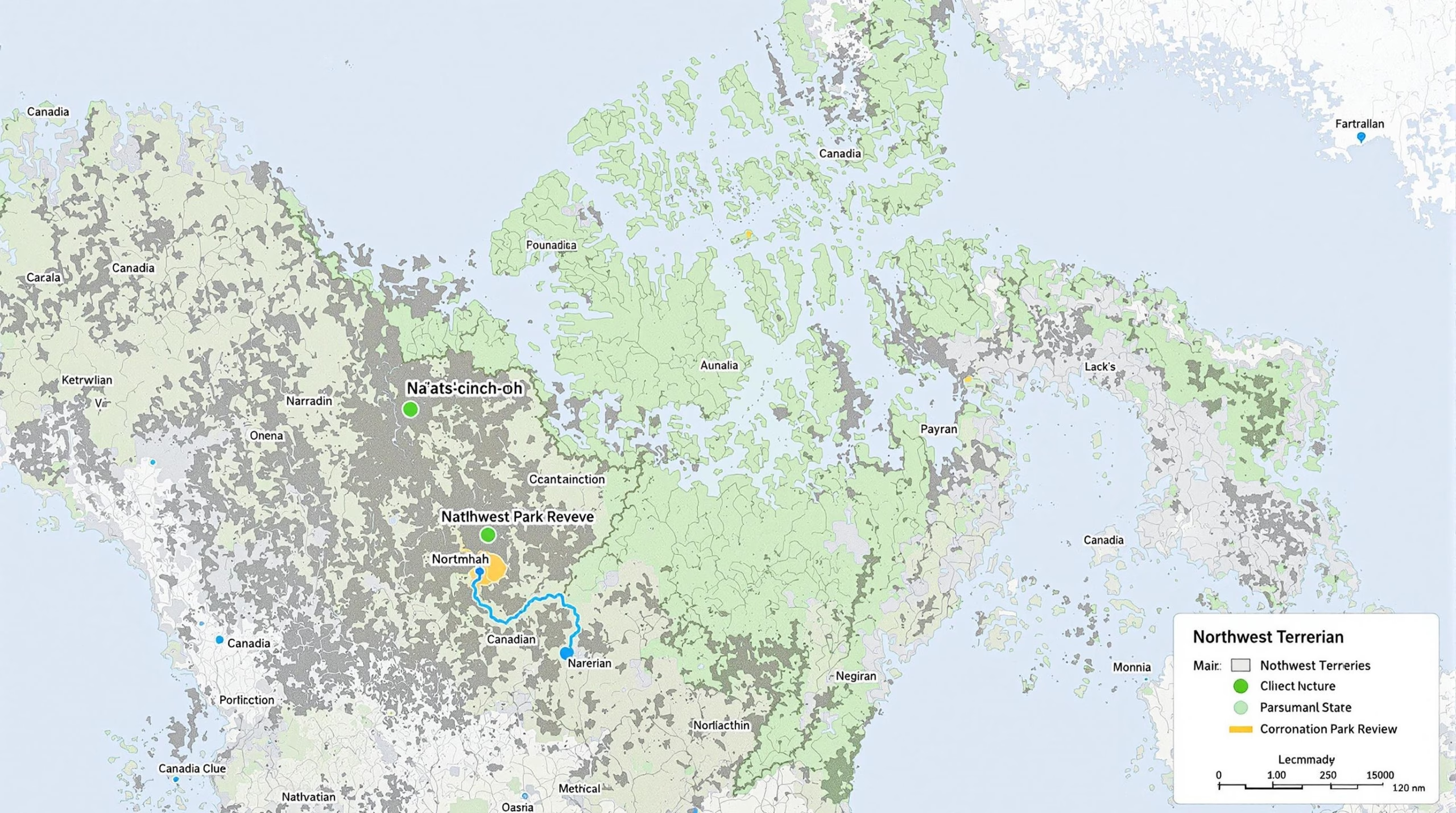
Nááts'ihch'oh National Park Reserve is situated in the Sahtu Region of Canada's Northwest Territories. The park lies near the southwestern corner of the territory, bordering the Yukon. Its location encompasses an area of pristine wilderness in the Mackenzie Mountains, an area known for its rugged terrain, glacial valleys, alpine tundra, and dense boreal forest.
The park's geographic coordinates roughly fall between 62°00'N to 63°30'N latitude and 127°00'W to 129°00'W longitude, placing it within a remote and ecologically significant area of northern Canada. These coordinates offer a general frame of reference for its location, although the park’s exact boundaries define a more intricate shape.
The park reserve's proximity to Nahanni National Park Reserve, a UNESCO World Heritage Site, enhances its ecological and cultural significance, creating a broader protected area across the region.
Boundaries
The boundaries of Nááts'ihch'oh National Park Reserve were carefully delineated during its establishment to balance conservation, traditional land use, and potential resource development. The park covers an area of approximately 4,850 square kilometers. Its southwestern boundary connects with Nahanni National Park Reserve, forming an extended protected corridor for wildlife and ecosystems unique to this region.
The park's boundaries also align closely with the Sahtu Settlement Area, reflecting its overlap with Indigenous traditional territories. This alignment was informed by consultations with the Sahtu Dene and Métis, whose cultural and historical ties to the land were integral to the boundary-setting process.
Significance of Boundary Designation
The designation of park boundaries was designed not only for ecological preservation but also to respect Indigenous rights and land claims. The establishment of the park included provisions to safeguard areas of cultural and spiritual importance, while maintaining flexibility for ongoing traditional land use.
The boundaries also account for resource management considerations, as some areas with significant subsurface potential for minerals or hydrocarbons were excluded from the park. This compromise reflects the dual aim of protecting wilderness and accommodating potential future development outside the park reserve's limits.
Accessibility
Due to its remote location, access to Nááts'ihch'oh National Park Reserve is limited. The nearest community is Tulita, located to the northeast of the park, while Norman Wells serves as a regional hub with air transportation services. Visitors typically reach the park via chartered flights or river routes, such as the South Nahanni River or other tributaries, which pass near or through park boundaries. These access routes reinforce the park's reputation as a destination for experienced wilderness explorers.
Relationship to Surrounding Areas
The park's boundaries not only connect it to Nahanni National Park Reserve but also position it within a broader network of protected areas in the Northwest Territories. This regional connectivity supports wildlife migration and ecological integrity across the Mackenzie Mountains, a critical habitat for species such as grizzly bears, Dall’s sheep, caribou, and peregrine falcons.
In summary, Nááts'ihch'oh National Park Reserve’s geographic coordinates and boundaries underscore its importance as a protected wilderness area that is both environmentally significant and deeply rooted in Indigenous cultural heritage. Its location and design reflect a careful balance of conservation priorities and traditional land use rights.
Geographic Context
Nááts'ihch'oh National Park Reserve is located in the remote wilderness of Canada’s Northwest Territories, making it a pristine and relatively untouched region of natural beauty. The park is situated near the Yukon border and forms part of the larger Nahanni ecosystem, which includes the adjacent Nahanni National Park Reserve.
Latitude and Longitude
The Nááts'ihch'oh National Park Reserve lies approximately between the coordinates of 62° N to 63° N latitude and 128° W to 130° W longitude. These geographic markers place the park in the heart of the Mackenzie Mountains, a rugged and dramatic landscape characterized by alpine terrain, river valleys, and striking geological formations.
Regional Boundaries
The park is located within the Sahtu Settlement Area, a region defined by land claim settlements with the Indigenous Sahtu Dene and Métis peoples. This geographic positioning underscores the park's dual ecological and cultural significance. To the south, it connects with Nahanni National Park Reserve, creating a vast, contiguous protected area that supports biodiversity and wildlife migration.
Surrounding Landscape
The park is dominated by dramatic mountain ranges, fast-flowing rivers, and expansive boreal forests. Key waterways such as the South Nahanni River and the Broken Skull River flow through or near the park, influencing its geography and supporting rich ecosystems. The area’s alpine meadows and rugged peaks, including the Nááts'ihch'oh mountain that gives the park its name, contribute to its extraordinary natural beauty and cultural importance.
Accessibility
Nááts'ihch'oh National Park Reserve’s remote location means that access is limited and often requires specialized transportation, such as chartered flights or trips by water. The park’s isolation preserves its wilderness character but also presents logistical challenges for visitors and researchers.
Geopolitical Context
The park’s location in the Northwest Territories places it within Canada’s northernmost administrative regions, an area known for its sparse population and vast, undeveloped landscapes. The park also plays a role in the federal and territorial governments’ efforts to protect ecologically significant areas while respecting Indigenous land rights and traditional uses.
Environmental Setting
The park’s geographic position within the Mackenzie Mountains and near the Arctic Circle means it experiences a subarctic climate. Summers are short and cool, while winters are long and harsh, with significant snowfall. This climate, combined with the unique topography, supports specialized flora and fauna adapted to the conditions of the northern wilderness.
Nááts'ihch'oh National Park Reserve’s geographic context not only defines its striking natural environment but also underscores its importance as a protected area for conservation, cultural heritage, and sustainable tourism.
Land Features and Terrain
Geographic Location and Coordinates
Nááts'ihch'oh National Park Reserve is located in the remote wilderness of Canada's Northwest Territories. The park lies within the Sahtu Region, bordering the western edge of Nahanni National Park Reserve. The park's approximate coordinates are between 62° and 64° latitude north and 127° and 129° longitude west. Its location places it within the Mackenzie Mountains, a rugged and largely untouched mountain range that defines much of the park's terrain.
Mountainous Landscape
The Nááts'ihch'oh National Park Reserve is renowned for its dramatic mountainous landscape. The park is named after Nááts'ihch'oh, a sacred mountain in Dene tradition that translates to "stands like a porcupine." This mountain is a striking feature of the park, with its sharp peaks and cultural significance. The region is characterized by jagged ridges, deep valleys, and vast alpine plateaus, offering a stunning backdrop for visitors and a vital habitat for wildlife.
River Systems and Watersheds
The park is home to critical headwaters of the South Nahanni River, a UNESCO World Heritage Site downstream in Nahanni National Park Reserve. The South Nahanni River and its tributaries, including the Broken Skull and Twitya Rivers, carve through the park's terrain, creating dramatic canyons and supporting diverse ecosystems. These waterways play a crucial role in the Mackenzie River Basin, one of the most significant freshwater systems in Canada.
Alpine and Subalpine Zones
Nááts'ihch'oh is dominated by alpine and subalpine zones, with elevations ranging from valley floors to high mountain peaks. The alpine areas are characterized by tundra-like conditions, with sparse vegetation adapted to harsh climates, including mosses, lichens, and hardy shrubs. Subalpine zones, on the other hand, feature denser vegetation, such as spruce, fir, and willow trees, interspersed with wildflower meadows during the summer months.
Karst Topography
The park contains notable examples of karst topography, a geological feature formed by the dissolution of soluble rocks such as limestone. This results in unique formations like sinkholes, caves, and underground streams. These features contribute to the park's ecological complexity and are of particular interest to researchers and adventurers.
Wildlife Habitats
The varied land features of Nááts'ihch'oh create a mosaic of habitats that support diverse wildlife. The rugged terrain provides critical habitat for mountain species such as Dall’s sheep and mountain goats, while the forests and valleys support populations of moose, woodland caribou, and grizzly bears. The waterways are crucial for aquatic species, including Arctic grayling and bull trout, and the park is also an important area for migratory birds.
Permafrost and Geological Features
A significant portion of the park lies within a region of discontinuous permafrost, where frozen ground underlays the surface soils in some areas. This geological feature influences vegetation patterns, water drainage, and overall ecosystem functioning. Additionally, the park's terrain showcases a variety of rock formations, from ancient sedimentary deposits to more recent glacial features, offering insights into the region's geological history.
Glacial Influence
The landscape of Nááts'ihch'oh has been heavily shaped by past glacial activity. U-shaped valleys, moraines, and glacial lakes are scattered throughout the park, providing evidence of the ice age's impact on the region. These features not only contribute to the park's scenic beauty but also serve as valuable records of Earth's climatic history.
Remote and Untouched Wilderness
One of the defining characteristics of Nááts'ihch'oh National Park Reserve is its isolation. The rugged terrain and lack of human infrastructure make it one of Canada's most pristine wilderness areas. This remoteness ensures that the park's ecosystems remain largely undisturbed, allowing nature to thrive in its purest form.
Nááts'ihch'oh's diverse land features and terrain form the foundation of its ecological and cultural importance, making it a vital part of Canada's protected natural heritage.
Access and Navigation
Location and Geographic Coordinates
Nááts'ihch'oh National Park Reserve is situated in the remote wilderness of Canada’s Northwest Territories, near the border with Yukon. The park lies at approximately 62.5°N latitude and 128.5°W longitude, encompassing a rugged and pristine landscape in the Mackenzie Mountains. These coordinates place the park in a subarctic region, characterized by dramatic peaks, alpine meadows, and winding rivers.
Access Points to the Park
Due to its remote location, accessing Nááts'ihch'oh National Park Reserve requires careful planning. There are no roads directly leading into the park, making it a destination primarily for adventurers seeking a backcountry experience. Visitors typically reach the park through one of the following methods:
- Charter Flights: Small aircraft can be chartered from Norman Wells or other nearby communities, landing at designated airstrips or on gravel bars along rivers within or near the park.
- Waterways: The South Nahanni River and the Broken Skull River are popular routes for paddlers, providing access to the park’s interior. Canoeing and kayaking are common ways to explore the park’s waterways.
- Hiking Trails: While trails are limited and often unmarked, experienced hikers can navigate the park using GPS devices and topographic maps.
Navigation Within the Park
Once inside Nááts'ihch'oh National Park Reserve, navigation can be challenging due to its vast, undeveloped terrain. Visitors need to be self-sufficient and prepared for wilderness travel. Key considerations include:
- Topographic Maps and GPS: Detailed maps and a reliable GPS device are essential for navigating the park’s rugged terrain. The Canadian government provides topographic maps specific to the region.
- River Travel: The park’s rivers, such as the Nahanni and Broken Skull, serve as natural corridors for exploration. Knowledge of river navigation and safety is crucial for water-based travel.
- Guided Expeditions: For visitors unfamiliar with backcountry navigation, guided tours led by experienced outfitters are available. These tours often include paddling, hiking, and wildlife observation.
Seasonal Access Considerations
Access to Nááts'ihch'oh National Park Reserve is heavily influenced by seasonal conditions. The park is most accessible during the summer months, from June to September, when rivers are navigable and weather conditions are less extreme. Key seasonal factors include:
- Spring Thaw (May to June): Snowmelt can cause high water levels and strong currents in rivers, making navigation challenging.
- Summer (July to August): This is the most popular season for visitors, with relatively mild weather and longer daylight hours.
- Fall (September to October): Cooler temperatures and shorter days mark the end of the peak season. Early snowfall may limit access.
- Winter (November to April): Harsh winter conditions, including heavy snowfall and extreme cold, render the park largely inaccessible. Only experienced winter adventurers should consider visiting during this time.
Recommended Visitor Preparation
Given the remote and undeveloped nature of Nááts'ihch'oh National Park Reserve, visitors must come adequately prepared for backcountry travel. Recommendations include:
- Permits: Obtain the necessary permits from Parks Canada before entering the park.
- Emergency Communication Devices: Carry a satellite phone or personal locator beacon (PLB) for emergencies, as there is no cell service in the park.
- Wilderness Skills: Proficiency in backcountry navigation, camping, and survival skills is essential for an enjoyable and safe visit.
- Provisions: Bring sufficient food, water, and gear, as there are no facilities or supply points within the park.
By understanding the park’s access points, navigation requirements, and seasonal challenges, visitors can fully appreciate the untouched beauty of Nááts'ihch'oh National Park Reserve while ensuring a safe and rewarding experience.
Geographic Significance
Location and Boundaries
Nááts'ihch'oh National Park Reserve is located in the southwestern corner of the Northwest Territories, Canada. The park lies within the Sahtu Settlement Area, an important region for Indigenous land claims and governance. The park's geographic coordinates are approximately latitude 62°N to 63.5°N and longitude 127°W to 130°W, spanning a remote and rugged wilderness area characterized by mountains, river valleys, and alpine tundra. It shares its southern boundary with Nahanni National Park Reserve, forming a contiguous protected area that is vital for ecological connectivity.
The park encompasses approximately 4,850 square kilometers of pristine wilderness, making it a significant addition to Canada's national park system. Its boundaries were carefully drawn to protect key ecosystems, wildlife habitats, and culturally significant sites, while also respecting the rights and traditional land uses of the local Indigenous communities, particularly the Sahtu Dene and Métis.
Ecological Importance
The geographic location of Nááts'ihch'oh places it within the Mackenzie Mountains, a region known for its dramatic landscapes and unique biodiversity. The park is part of the larger Mackenzie River Basin, which is one of the most important freshwater systems in North America. Its location ensures the protection of headwaters for the South Nahanni River, a UNESCO World Heritage Site due to its outstanding environmental and cultural value.
Because of its northern latitude, the park experiences a subarctic climate, with long, cold winters and short, cool summers. This environment supports a variety of ecosystems, including boreal forests, alpine meadows, and tundra. The park's isolation and intact habitats make it a haven for wildlife, such as grizzly bears, Dall's sheep, mountain goats, caribou, and a range of bird species, including golden eagles and peregrine falcons.
Cultural and Indigenous Significance
The geographic location of Nááts’ihch’oh is deeply intertwined with its cultural and spiritual importance. The park is named after Nááts'ihch'oh, a mountain that holds sacred meaning for the Sahtu Dene people. The name translates to "stands like a porcupine," referencing the appearance of the mountain's ridges. This sacred peak is not only a landmark but also a symbol of cultural identity and spiritual connection for the local Indigenous communities.
The park's location within the Sahtu Settlement Area also underscores its importance in the context of Indigenous land claims and governance. The Sahtu Dene and Métis have historically used this land for hunting, fishing, trapping, and other traditional activities. The geographic boundaries of the park were established in consultation with these communities to ensure that their cultural and subsistence practices are respected and preserved.
Connectivity to Nahanni National Park Reserve
Nááts'ihch'oh’s geographic proximity to Nahanni National Park Reserve enhances its ecological and conservation significance. Together, these two parks form a larger protected area that safeguards critical wildlife corridors and migratory routes. This connectivity is essential for species such as caribou and grizzly bears, which require vast, undisturbed territories to thrive. The combined area of these parks also helps mitigate the effects of climate change by preserving diverse ecosystems and promoting resilience in northern landscapes.
Remote Wilderness and Accessibility
The remote nature of Nááts'ihch'oh National Park Reserve adds to its geographic significance. Accessible primarily by air or via challenging overland routes, the park is one of the most pristine and undisturbed wilderness areas in Canada. Its remoteness not only protects its ecosystems from human impact but also offers unique opportunities for visitors seeking solitude and adventure in a rugged, natural setting.
Conclusion on Geographic Significance
The geographic significance of Nááts'ihch'oh National Park Reserve lies in its role as a critical ecological and cultural landscape in Canada's Northwest Territories. Its location within the Mackenzie Mountains and Sahtu Settlement Area ensures the protection of natural ecosystems, water resources, and Indigenous heritage. The park's proximity to Nahanni National Park Reserve further enhances its value as part of a larger conservation network, making it a vital component of Canada's efforts to preserve its northern wilderness.
Nááts'ihch'oh National Park Reserve, defined by its geographic coordinates and boundaries, is more than just a remote wilderness—it's a sanctuary for diverse ecosystems and a testament to Indigenous heritage. As part of a vital conservation corridor, the park balances ecological preservation, traditional land use, and the natural beauty of the Mackenzie Mountains. Whether you're drawn by its latitude and longitude or its cultural and environmental significance, Nááts'ihch'oh is a destination worth protecting and exploring.