Located in the heart of Ontario, Canada, Georgian Bay Islands National Park is a natural gem defined by its unique geographic location and breathtaking beauty. Positioned at approximately 44.9667° N latitude and 79.8667° W longitude, this park is part of the larger Georgian Bay ecosystem, often referred to as the "Sixth Great Lake." Comprising 63 islands and characterized by rugged landscapes of the Canadian Shield, the park offers unparalleled experiences for adventurers, boaters, and nature lovers. Let’s explore its exact coordinates, geographic features, and visitor tips in greater depth.
## Precise Geographic Location
Coordinates of Georgian Bay Islands National Park
Georgian Bay Islands National Park is situated in Ontario, Canada, within the iconic Georgian Bay region of Lake Huron. The park's approximate central coordinates are 44.9667° N latitude and 79.8667° W longitude. These coordinates place it in the southern part of Georgian Bay, near the town of Honey Harbour, which serves as a gateway to the park.
Position within Georgian Bay
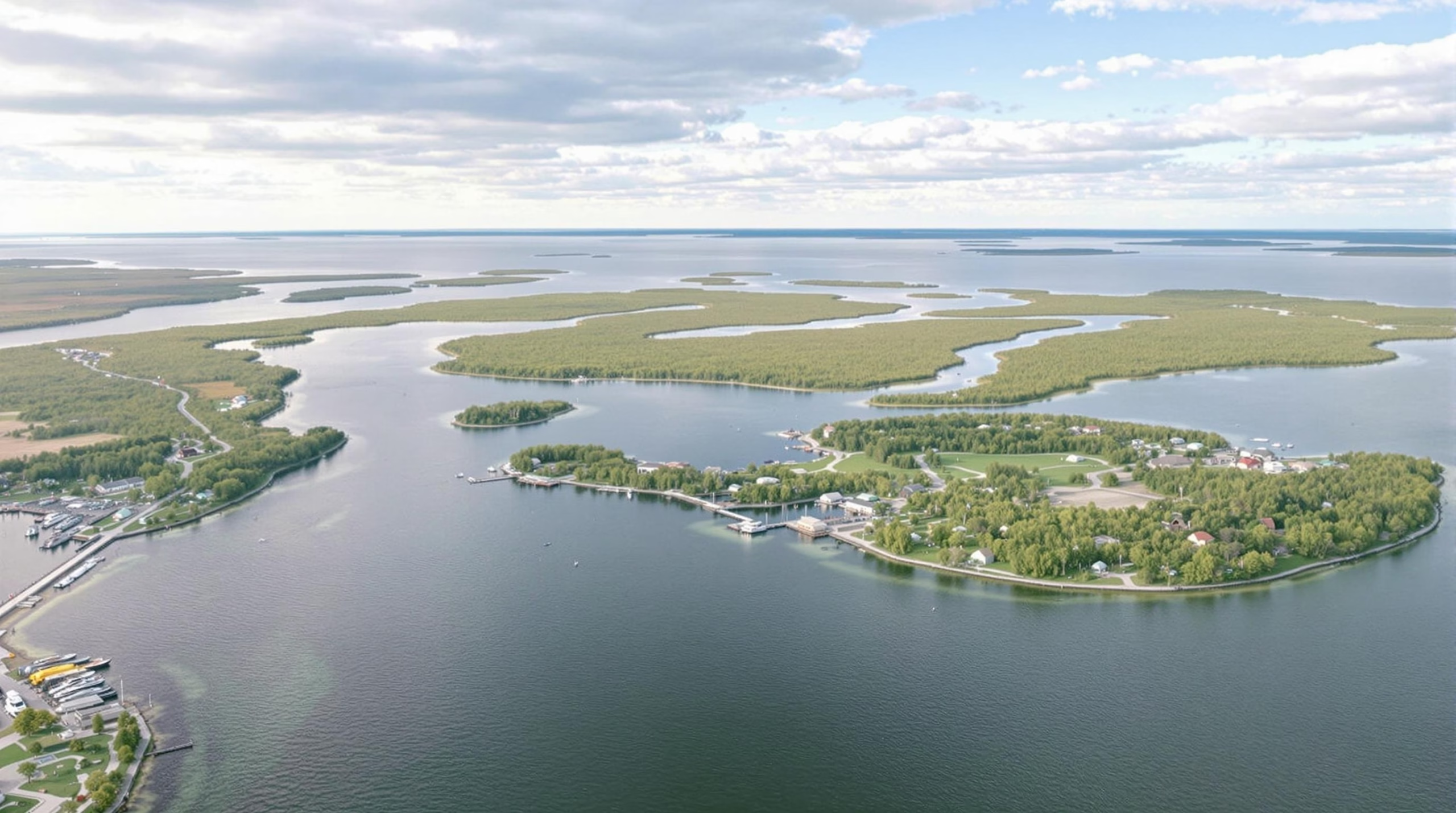
The park is composed of 63 small islands and islets, scattered across the southeastern portion of Georgian Bay. The majority of these islands are accessible only by boat, adding to the park's remote and pristine appeal. The largest and most well-known island in the park is Beausoleil Island, which serves as the main hub for visitor activities and facilities.
Regional Context
Georgian Bay Islands National Park is part of the larger Georgian Bay ecosystem, often referred to as the "Sixth Great Lake" due to its vast size and unique ecological features. The park itself lies within the Canadian Shield, a rugged and ancient geological region marked by exposed granite bedrock, rolling hills, and dense forests.
Water Systems and Coastal Features
The park's islands are surrounded by the clear, freshwater expanse of Georgian Bay, which is a segment of the Great Lakes basin. The bay's waters are dotted with rocky outcrops, sandy coves, and sheltered inlets, offering a dynamic mix of aquatic habitats. These water systems support a range of ecosystems, from wetlands to open water zones, and are vital to the park's biodiversity.
Accessibility and Proximity
Georgian Bay Islands National Park is located approximately 150 kilometers (93 miles) north of Toronto, making it a popular destination for day trips and weekend getaways. The park's proximity to urban centers while maintaining a remote and natural setting makes it an accessible yet secluded retreat for nature enthusiasts.
Park Boundaries and Access Points
Geographic Boundaries
Georgian Bay Islands National Park is located in southeastern Ontario, Canada, within the iconic Georgian Bay, a northeastern arm of Lake Huron. The park is an archipelago of 63 islands, spanning a range of landscapes from rugged granite outcroppings to lush forests. Its precise geographic coordinates place it at approximately 44.8833° N latitude and 79.8667° W longitude, making it one of Canada’s most accessible yet serene natural escapes.
The park is bounded on all sides by the waters of Georgian Bay, with its terrain forming part of the Canadian Shield, a region known for its ancient rock formations and diverse ecosystems. Notable islands within the park include Beausoleil Island, the largest and most frequently visited, as well as smaller islands like Bone Island and Giant’s Tomb Island, each offering unique natural features and habitats.
Access Points
Access to Georgian Bay Islands National Park is primarily water-based, as the park is entirely composed of islands. The main gateway for visitors is the town of Honey Harbour, located on the mainland. From Honey Harbour, visitors can board water taxis or private boats to reach the islands. Parks Canada operates a passenger ferry, the DayTripper, which provides seasonal service to Beausoleil Island, offering a reliable and convenient transport option for visitors without their own boats.
For paddling enthusiasts, kayaks and canoes provide an adventurous means of exploring the islands. The park’s proximity to major urban centers like Toronto, which is approximately a 2-hour drive away, adds to its accessibility for day trips and weekend getaways.
Navigational Considerations
Visitors are encouraged to use marine charts and GPS devices when navigating the waters around Georgian Bay Islands National Park. The bay’s waters can be challenging due to rocky outcroppings, shallow areas, and shifting weather conditions. Parks Canada provides detailed maps and orientation materials to assist visitors in planning their journeys safely.
Seasonal Accessibility
The park is open year-round, but access is highly seasonal. The ferry service and many visitor facilities operate primarily from late spring to early fall. During the colder months, access to the islands becomes limited to those with specialized equipment, such as ice boats or snowmobiles, depending on ice conditions.
Visitor Entry Points
Beausoleil Island serves as the main hub for park activities, with designated docking areas for boats and kayaks. The island features several official entry points, including Cedar Spring, which is equipped with visitor facilities such as picnic areas, restrooms, and camping sites.
Smaller islands within the park have limited or no docking facilities, and visitors are advised to research and plan accordingly if they wish to explore beyond Beausoleil. Permits are required for camping and certain recreational activities, and they can be obtained through Parks Canada’s reservation system.
Tips for First-Time Visitors
- Plan Ahead: Check the Parks Canada website for ferry schedules, seasonal closures, and weather updates.
- Boating Permits: Ensure your boat is registered and equipped with the necessary safety gear.
- Pack Smart: Bring essentials like water, sunscreen, and sturdy footwear, especially if you plan to hike or explore the islands.
- Respect the Ecosystem: Follow Leave No Trace principles and respect wildlife habitats to preserve the park’s natural beauty.
By understanding the park’s boundaries and access points, visitors can fully embrace the adventure and tranquility that Georgian Bay Islands National Park has to offer.
Digital Navigation and Mapping
Utilizing Digital Tools for Navigation
Digital navigation has revolutionized the way visitors explore natural parks, including Georgian Bay Islands National Park. Modern tools such as GPS devices, smartphone apps, and online mapping platforms make it easier than ever to plan and execute a trip to this remarkable destination. With precise geolocation capabilities, these tools allow visitors to pinpoint the park's exact location at 44.8833° N latitude and 79.8667° W longitude, ensuring accurate orientation and planning.
Mapping applications like Google Maps or Parks Canada's official app provide interactive maps of the park, showcasing hiking trails, camping spots, and points of interest. These platforms often include real-time updates about accessibility, weather conditions, and even warnings about wildlife activity, ensuring a safe and enjoyable experience for every visitor.
Geospatial Data and Park Exploration
Georgian Bay Islands National Park benefits significantly from advancements in geospatial technology. As part of the Canadian Shield, the park's rugged terrain and diverse ecosystems are well-documented through satellite imagery and digital cartography. This data is not just useful for visitors but also aids in the park's conservation efforts, as it allows researchers and park staff to monitor environmental changes over time.
Digital mapping systems also highlight the intricate network of islands within the park, making it easier for boaters and kayakers to navigate the waters of Georgian Bay. Detailed maps provide information on water depths, currents, and safe docking areas, which are essential for a smooth and secure journey.
Online Resources for Trip Planning
Parks Canada offers a range of online resources to assist visitors in planning their trip to Georgian Bay Islands National Park. The official website provides downloadable maps, trail guides, and information about transportation, including boat access to the islands. Additionally, users can access seasonal updates about the availability of facilities and services, as well as any temporary restrictions.
For those seeking a more immersive experience, virtual tours and interactive maps allow potential visitors to explore the park digitally before their trip. These tools provide a sense of the park's layout and natural beauty, inspiring more people to visit and experience its wonders in person.
Enhancing Accessibility with Mobile Apps
Mobile applications have become a cornerstone of digital navigation in national parks. Many apps are designed to work offline, ensuring that visitors can access essential information even in remote areas with limited connectivity. Popular features include GPS-tracking for hikes, route suggestions, and informational guides about the park's flora, fauna, and cultural history.
For Georgian Bay Islands National Park, these applications often include augmented reality (AR) features, enabling users to point their phones at a specific location to learn more about its significance. This blend of technology and education enhances the visitor experience while promoting awareness of the park's ecological and cultural heritage.
The Role of Canadian Geographical Names Database (CGNDB)
The Canadian Geographical Names Database (CGNDB) plays an integral role in digital navigation by maintaining accurate and official geographic names across the country, including Georgian Bay Islands National Park. This database ensures consistency in naming conventions and provides a reliable reference for map developers, researchers, and the general public.
By integrating CGNDB data, digital mapping tools can offer precise and authoritative information about the park's landmarks and features. This not only aids in navigation but also supports cultural preservation by promoting the use of indigenous and historical place names.
Preparing for a Seamless Adventure
Digital navigation and mapping tools are indispensable for visitors to Georgian Bay Islands National Park. Whether you’re planning a hike on the island trails, kayaking through its waters, or camping under the stars, these tools provide the resources needed to make your adventure safe, efficient, and memorable. By leveraging modern technology alongside traditional conservation efforts, the park ensures that its natural beauty is both accessible and protected for generations to come.
Physical Geography Features
Geographic Location
Georgian Bay Islands National Park is located in Georgian Bay, a northeastern arm of Lake Huron in Ontario, Canada. The park lies approximately between the coordinates 44.8636° N latitude and 79.8661° W longitude, placing it in a prime location within the Great Lakes Basin. It is part of the Southern Ontario region and is accessible to visitors from nearby urban centers such as Toronto and Barrie.
Island Composition and Distribution
The park is a unique collection of 63 small islands, each contributing to the park's diverse ecosystem. The main island, Beausoleil Island, is the largest and most developed, offering a range of visitor facilities and natural attractions. The islands vary in size, from larger landmasses with forests and hiking trails to smaller rocky outcrops that serve as critical habitats for wildlife. Their distribution creates an intricate archipelago that boasts stunning landscapes and rich biodiversity.
Geological Formation and the Canadian Shield
Georgian Bay Islands National Park is part of the Canadian Shield, one of the world's oldest geological formations. The rugged terrain is characterized by exposed granite bedrock, sculpted over millennia by glacial activity. This unique geological foundation gives the islands their iconic pink and gray rock formations, which contrast beautifully with the surrounding blue waters of Georgian Bay. The park also features areas of glacial till and sandy beaches, offering a variety of landscapes within a relatively small area.
Coastal Landscapes and Shorelines
The park's islands are surrounded by a mix of rocky shorelines, sandy coves, and marshy wetlands. The coastal landscapes are shaped by the persistent action of wind and water, resulting in stunning features like wave-swept cliffs and quiet, sheltered bays. These diverse shorelines provide critical habitats for aquatic species and offer breathtaking vistas for visitors exploring by boat or on foot.
Water Systems and Ecosystems
Georgian Bay Islands National Park is intrinsically linked to the water systems of Lake Huron and the broader Great Lakes Basin. The park's location within Georgian Bay creates a freshwater ecosystem that is home to an array of aquatic species, including fish such as bass, pike, and muskellunge. The interplay between water and land supports unique ecosystems, such as coastal wetlands, which serve as breeding grounds for numerous bird species and amphibians.
Climate and Seasonal Variations
The park experiences a humid continental climate, with warm summers and cold, snowy winters. Seasonal variations play a significant role in shaping the park's physical geography. Summers bring lush greenery and warm waters ideal for swimming and kayaking, while winters transform the islands into a serene, snow-covered wonderland. These shifts in climate also influence the flora and fauna, adding to the park's rich biodiversity and ecological significance.
Visitor Navigation Information
Transportation Options
Georgian Bay Islands National Park, located in Ontario, Canada, is accessible only by water, making it one of the more unique national parks in the country. Visitors can reach the park by private boats or water taxis. The park's main entry point is through Honey Harbour, a small community that serves as a gateway for water transportation. For those without their own boats, the DayTripper, a Parks Canada-operated passenger ferry, is available during the summer months to transport visitors to Beausoleil Island, the park's largest and most popular island.
Seasonal Accessibility
The park is open year-round, but accessibility varies significantly depending on the season. During the warmer months, from late spring to early autumn, water transportation options are plentiful, and the park is bustling with recreational activities. In contrast, winter access is more limited, as frozen waters can make navigation challenging. While the park remains open for winter enthusiasts, visitors should plan accordingly and ensure they have the proper equipment and knowledge for cold-weather exploration.
Facilities and Amenities
Georgian Bay Islands National Park offers a range of facilities designed to enhance visitor experiences. Beausoleil Island features picnic areas, restrooms, and camping facilities, including both front-country and backcountry campsites. Visitors can also find rustic cabins available for rental, providing a more comfortable overnight option. Docking facilities are available for boaters, and designated swimming areas are perfect for cooling off during the summer. Interpretive signage and visitor information boards are scattered throughout the park to assist guests in navigating and learning about the unique features of the area.
Guided Tours and Programs
Parks Canada offers a variety of guided tours and educational programs to enrich visitors' understanding of the park's natural and cultural heritage. Interpretive hikes led by knowledgeable guides provide insights into the park's diverse ecosystems, indigenous history, and geological formations. Seasonal programs may include wildlife viewing tours, cultural heritage workshops, and stargazing events. These guided experiences are an excellent way for visitors to immerse themselves in the park's natural beauty and historical significance.
Navigation Tips
When visiting Georgian Bay Islands National Park, it’s essential to come prepared with navigation tools. Maps of the park, available at the visitor center and online, are crucial for exploring its network of trails and waterways. GPS devices and nautical charts are recommended for boaters to safely traverse the bay's waters and locate various islands. Cell phone reception can be limited in certain areas, so downloading maps and information ahead of time is advisable. Additionally, visitors should be mindful of weather conditions, as sudden changes can impact water travel and outdoor activities.
Georgian Bay Islands National Park’s stunning landscapes and remote accessibility set it apart as a must-visit destination for nature lovers. With its central coordinates anchoring the southeastern Georgian Bay, visitors can easily navigate to this pristine park while enjoying its unique geological and ecological highlights. Whether you’re kayaking to Beausoleil Island, exploring rugged hiking trails, or enjoying the serene beauty of the Canadian Shield, Georgian Bay Islands National Park offers something for every adventurer. Start planning your journey today by leveraging digital tools, ferry services, and interactive maps to make the most of your trip!