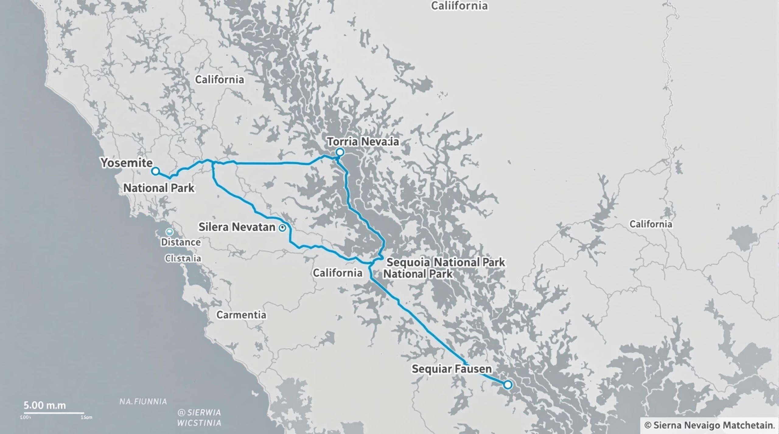
Yosemite National Park and Sequoia National Park, two of California’s most iconic destinations, are approximately 100 miles (160 km) apart in a straight line. However, due to rugged terrain and limited road connections, the actual driving distance ranges from 130 to 215 miles (209 to 346 km), with travel times between 2.5 to 5 hours. This guide explores the best routes, estimated travel time, seasonal considerations, and transportation options to help you plan a smooth journey between these stunning national parks.
Understanding the Distance
Geographic Location of Yosemite and Sequoia National Parks
Yosemite National Park and Sequoia National Park are two of California’s most famous national parks, both located in the Sierra Nevada mountain range. Yosemite is situated in the central region of the state, while Sequoia lies to the south. Although they are relatively close to each other, the rugged terrain and park boundaries require visitors to take specific routes to travel between them.
Distance Between Yosemite and Sequoia National Park
The direct distance between the two parks is approximately 100 miles (160 kilometers). However, due to the mountainous landscape and limited road connections, the actual driving distance is significantly longer. The most commonly used routes cover between 130 to 215 miles (209 to 346 kilometers), depending on the chosen path and entry points.
Estimated Travel Time
Driving between Yosemite and Sequoia National Park generally takes between 2.5 to 5 hours. The time varies based on factors such as road conditions, weather, and traffic. During peak tourist seasons, especially in summer, the roads may experience congestion, leading to longer travel durations.
Best Routes Between the Parks
There are multiple routes travelers can take to journey between Yosemite and Sequoia National Park:
-
Via Highway 41 and Highway 180 (Recommended Route)
- Distance: Approximately 160 miles (257 km)
- Estimated Travel Time: About 3.5 to 4.5 hours
- This route takes travelers through Fresno, providing access to gas stations, dining options, and lodging. It is one of the most efficient routes, offering a balance between travel time and accessibility.
-
Via Highway 41 and Highway 198 (Scenic Route)
- Distance: Approximately 215 miles (346 km)
- Estimated Travel Time: About 4.5 to 5 hours
- This route takes visitors through Three Rivers, a small town near Sequoia’s entrance. While longer, it offers beautiful landscapes and access to additional recreational areas.
-
Via Highway 49 and Highway 41 (Alternative Route)
- Distance: Approximately 180 miles (290 km)
- Estimated Travel Time: About 4 to 4.5 hours
- This route includes a scenic drive through small historic Gold Rush towns, making it an enjoyable option for those interested in a more immersive travel experience.
Seasonal Considerations for Travel
The time of year plays a crucial role in planning a trip between Yosemite and Sequoia National Park:
- Summer (June to September): Roads are fully accessible, but traffic congestion is common. Travelers should expect delays and book accommodations in advance.
- Fall (October to November): Cooler temperatures and fewer crowds make this an ideal time for travel. However, early snowfall may impact higher-elevation roads.
- Winter (December to March): Some roads, including the Tioga Pass in Yosemite, are closed due to snow. Chains may be required for vehicles, and alternate routes should be considered.
- Spring (April to May): Melting snow creates stunning waterfalls, but some roads may still be closed. Travelers should check road conditions before departure.
Alternative Transportation Options
For those who prefer not to drive, alternative transportation options are available, though limited:
- Public Transportation: There are no direct public transportation services between the parks. However, visitors can take buses from Fresno to reach specific park areas.
- Guided Tours: Some tour companies offer multi-day trips covering both Yosemite and Sequoia National Parks, providing transportation and guided experiences.
- Shuttle Services: While both parks offer internal shuttle services, they do not connect directly. Visitors must rely on private vehicles or guided tours for inter-park travel.
Understanding the distance and travel logistics between Yosemite and Sequoia National Park is crucial for planning a smooth and enjoyable trip. By considering the best routes, seasonal factors, and available transportation options, visitors can make the most of their journey between these two breathtaking destinations.
Transportation Options and Routes
Driving Between Yosemite and Sequoia National Parks
Driving is the most convenient and flexible way to travel between Yosemite National Park and Sequoia National Park. The distance between the two parks is approximately 130 to 150 miles, depending on the route taken, with an average driving time of 3.5 to 4.5 hours.
The most common driving routes include:
- Via CA-41 and CA-180 (Fresno Route) – This is the most direct and commonly used route. Travelers exit Yosemite via CA-41 South, pass through Fresno, and continue on CA-180 East, entering Kings Canyon National Park before reaching Sequoia National Park.
- Via CA-41 and CA-198 (Visalia Route) – Another option is to take CA-41 South from Yosemite, then use CA-198 East through Visalia to reach the Ash Mountain Entrance of Sequoia National Park. This route passes through the city of Visalia, a good stop for food, fuel, and lodging.
- Scenic Route via Tioga Pass (Seasonal) – If traveling during summer or early fall, visitors can take Tioga Road (CA-120) to experience breathtaking high-altitude scenery before heading south to Sequoia. However, this option adds significant travel time and is closed in winter.
Public Transportation Options
While driving is the preferred method, public transportation is available with some limitations.
- YARTS (Yosemite Area Regional Transportation System) – This bus service connects Yosemite to Fresno, where travelers can transfer to other regional transportation options.
- Greyhound and Amtrak – Visitors can take an Amtrak train or Greyhound bus to Fresno or Visalia and then use local transit services or rental cars to reach Sequoia National Park.
- Sequoia Shuttle – Operating seasonally, this shuttle provides service from Visalia to Sequoia National Park, making it a viable option for those without a car.
Shuttle Services and Tours
For those who prefer guided transportation, several tour companies offer multi-park tours that include both Yosemite and Sequoia National Parks. These tours typically include transportation, park entry fees, and guided sightseeing experiences. Some companies also offer private shuttle services between the parks.
Seasonal Considerations for Travel
- Winter Travel – Snow and road closures can impact routes, particularly in higher elevations. Tioga Pass (CA-120) and Glacier Point Road in Yosemite typically close from late fall to early summer. Additionally, tire chains may be required on some roads.
- Summer Peak Season – Roads can experience heavy traffic, especially near Yosemite Valley and Sequoia’s Giant Forest area. Travelers should plan for potential delays and make reservations for accommodations well in advance.
- Spring and Fall Travel – These shoulder seasons offer milder weather and fewer crowds, making them ideal for road-tripping between the parks. However, some park services may be limited.
By understanding the available transportation options and optimal routes, visitors can efficiently plan their journey between Yosemite and Sequoia National Parks while enjoying the stunning scenery along the way.
Planning Your Journey
Distance and Travel Logistics
When planning a trip between Sequoia National Park and Yosemite National Park, understanding the distance and travel logistics is crucial. The two parks are approximately 130 to 150 miles apart, depending on the route taken. The drive time typically ranges from 3.5 to 5 hours, factoring in road conditions, traffic, and seasonal closures.
The journey between the parks takes travelers through California’s Sierra Nevada region, offering stunning landscapes along the way. Since there is no direct road cutting through the wilderness between the parks, visitors must navigate via highways and scenic byways.
Best Routes Between Parks
There are several routes to choose from when traveling between Sequoia and Yosemite:
-
Via CA-41 North (Fresno Route) – Approx. 4 to 4.5 Hours
- This is one of the most popular and straightforward routes.
- Drive north from Sequoia National Park to Fresno via CA-198 and CA-180.
- Take CA-41 North from Fresno straight to Yosemite’s South Entrance.
-
Via CA-99 and CA-140 (Merced Route) – Approx. 4.5 to 5 Hours
- Travel from Sequoia to Visalia, then take CA-99 North to Merced.
- From Merced, take CA-140 East into Yosemite Valley.
- This route is often used when accessing Yosemite’s western entrances.
-
Via Tioga Pass (Seasonal, Eastern Sierra Route) – Approx. 5+ Hours
- Travel through Sequoia and head north via US-395.
- Enter Yosemite through the Tioga Pass Entrance (open seasonally, typically late May to October).
- This route is highly scenic but only accessible in warmer months.
Choosing the best route depends on weather conditions, time of year, and personal preferences.
Optimal Timing and Seasonal Considerations
Timing your trip correctly is essential when traveling between Sequoia and Yosemite. Here are key seasonal factors to consider:
- Spring (March – May): Waterfalls in both parks are at their most spectacular, but some higher elevation roads may still be closed.
- Summer (June – August): Peak tourist season with warm weather, but expect heavy crowds and limited parking.
- Fall (September – November): Fewer crowds, pleasant weather, and beautiful autumn colors in some areas.
- Winter (December – February): Snowfall can lead to road closures, especially in Yosemite. Tioga Pass is closed in winter, requiring an alternate route via Fresno or Merced.
Transportation Options
Most visitors drive their own vehicles or rent a car, as public transportation options between the parks are limited. However, here are some alternatives:
- Public Transit: YARTS (Yosemite Area Regional Transportation System) provides bus services to Yosemite from Merced, but there is no direct connection from Sequoia.
- Guided Tours: Some tour companies offer multi-day trips covering both parks. This can be a convenient option for those who prefer not to drive.
- Shuttle Services: While both parks have internal shuttle systems, they do not connect directly, so a personal vehicle or other transport is required for the journey between them.
By carefully planning the route, considering seasonal factors, and choosing the right transportation, travelers can ensure a smooth and enjoyable journey between these two breathtaking national parks.
Stopover Points and Breaks
Traveling between Sequoia National Park and Yosemite National Park is a scenic journey that can take around 4 to 5 hours by car, depending on the chosen route and traffic conditions. Since the drive covers a significant distance, it’s beneficial to plan for stopovers and breaks, both for relaxation and to explore additional attractions along the way.
Fresno: A Convenient Midpoint
Fresno serves as a logical stopover point for travelers driving between the two parks. Located approximately midway between Sequoia and Yosemite, Fresno offers a variety of amenities, including:
- Dining options ranging from fast food to sit-down restaurants
- Fuel stations for refueling before continuing the journey
- Grocery stores for stocking up on supplies
- Lodging options for those who prefer an overnight stay
Additionally, Fresno is home to the Fresno Chaffee Zoo and the Forestiere Underground Gardens, which can provide an interesting detour for those with extra time.
Oakhurst: Gateway to Yosemite
For travelers approaching Yosemite from the south, Oakhurst is another excellent place to take a break. This small town offers:
- Restaurants and cafes to grab a meal
- Convenient lodging options for those who want to break up the drive
- Scenic views as it sits near the Sierra Nevada foothills
- Proximity to Bass Lake, a great spot for a relaxing walk or picnic
Oakhurst is located along Highway 41, one of the primary routes into Yosemite National Park, making it a strategic stop before entering the park.
Visalia: A Stop Near Sequoia National Park
If beginning the journey from Sequoia National Park, Visalia is a good stop for supplies and food. This charming city offers:
- Grocery stores and major retail chains for last-minute necessities
- Varied dining options, from casual eateries to local favorites
- Fuel stations for refueling before heading toward Yosemite
Visalia is often considered the gateway to Sequoia and Kings Canyon National Parks, making it a natural starting point for many travelers.
Scenic Breaks Along the Route
For those who prefer to enjoy the journey with scenic rest stops, consider these locations:
- Kings Canyon Scenic Byway – If time allows, a detour through Kings Canyon offers breathtaking views and opportunities for short hikes.
- Kaweah River – A great spot to stretch your legs and enjoy the rushing waters along the way.
- Coarsegold Historic Village – A small stop with local shops and a glimpse into Gold Rush-era history.
Planning for Comfort and Safety
Given the length of the drive, it’s essential to plan for rest stops, especially during summer when temperatures can be high. Be sure to:
- Carry sufficient water and snacks
- Plan fuel stops, as gas stations can be sparse in certain areas
- Check road conditions, particularly in winter when snow and ice may affect routes
By incorporating well-timed breaks and stopovers, travelers can enhance their journey, making the drive between Sequoia and Yosemite National Parks not just efficient, but also enjoyable.
Essential Travel Tips
Plan Your Route in Advance
When traveling between Yosemite National Park and Sequoia National Park, planning your route in advance is crucial. The parks are approximately 130 to 150 miles apart, depending on the chosen route. The most common driving routes include:
- Via CA-41 S and CA-180 E – Approximately 3.5 to 4.5 hours of driving time, passing through Fresno and offering scenic views.
- Via CA-99 S and CA-198 E – Slightly longer but provides access to Visalia, a good stop for supplies or rest.
Due to winding mountain roads and potential traffic delays, it's best to check road conditions before departure, especially in winter when snow may cause closures.
Consider the Best Time to Travel
The best time to travel between Yosemite and Sequoia depends on weather conditions and road accessibility:
- Spring (April – June): Ideal for waterfalls in Yosemite and lush landscapes in Sequoia. Some higher-elevation roads may still have snow.
- Summer (July – September): Peak tourist season with warm temperatures. Expect crowds, especially in Yosemite Valley.
- Fall (October – November): Cooler temperatures and fewer visitors. Great for hiking and photography.
- Winter (December – March): Snowfall may close roads, especially Tioga Pass and certain routes within Sequoia. Chains may be required.
Fuel and Supply Stops
Gas stations are limited within both parks, so fuel up before entering. The best places to stop for fuel and supplies include:
- Fresno: A major city with multiple gas stations, grocery stores, and accommodations.
- Oakhurst: Located near Yosemite’s south entrance, good for last-minute necessities.
- Visalia: A convenient stop when heading towards Sequoia, with restaurants and lodging options.
Accommodation Planning
If you're planning an overnight stay between the parks, options include:
- Fresno or Visalia: Affordable hotels and easy access to both parks.
- Lodges within the parks: Yosemite's Ahwahnee Hotel, Wuksachi Lodge in Sequoia, or campgrounds if available.
- Nearby towns: Oakhurst (near Yosemite) or Three Rivers (near Sequoia) offer alternative lodging.
Pack for Changing Weather
Weather conditions can vary significantly between Yosemite and Sequoia due to differences in elevation. Essentials include:
- Layers: Temperatures can vary from warm valley floors to cooler higher elevations.
- Hiking gear: Comfortable shoes, sun protection, and plenty of water.
- Snow chains (Winter): Required in some areas if traveling during snowy months.
Be Aware of Park Regulations
Both Yosemite and Sequoia have specific regulations to ensure visitor safety and conservation:
- Entrance Fees: A single-entry fee applies per park, or consider the America the Beautiful Pass for access to multiple national parks.
- Wildlife Safety: Avoid feeding animals and store food securely.
- Fire Restrictions: Check for fire bans, particularly during dry summer months.
Maximize Your Time
To make the most of your visit:
- Start early: Arriving at the parks early helps avoid crowds.
- Use shuttle services: Yosemite has a free shuttle system to reduce traffic congestion.
- Prioritize must-see attractions: Focus on top sites like Glacier Point (Yosemite) and General Sherman Tree (Sequoia) if time is limited.
By following these essential travel tips, you can ensure a smoother and more enjoyable journey between Yosemite and Sequoia National Parks.
The journey between Yosemite and Sequoia National Parks is an adventure in itself, offering varying travel routes, seasonal considerations, and breathtaking scenery. Whether you drive, take guided tours, or stop at key points along the route, careful planning ensures a seamless trip. Ready to start exploring? Begin planning your Yosemite-Sequoia road trip today! 🚗🌲🏔